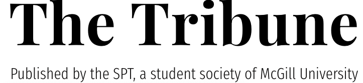
U3 students Hannah Rebentisch, Caroline Thompson, Hannah Ker, Jan Oledan, and Cameron Power, with various concentrations in geography and geographic information systems (GIS), are bringing the mission of mapping to McGill. After attending the Humanitarian OpenStreetMap Team conference in September 2017, they met representatives from a global organization called YouthMappers, which seeks to build students’ capacities to map their own communities and build resiliency against natural disasters. Returning to McGill, they created the McGill Open Mapping Group (OMG), the first chapter of YouthMappers at any Canadian university.
GIS, the system used in basically all mapping efforts, is designed to analyze, represent, and interpret spatial data in order to understand spatial relationships or patterns. GIScience refers to the science behind implementing and conceptualizing the actual GIS models. While McGill offers a geography minor in Geographic Information Systems and Remote Sensing, OMG seeks to encourage the participation of all McGill students by using a free, open source software, rather than the paid—and notoriously difficult—ArcGIS software used in most McGill courses.
“We try and raise awareness on campus of the importance of mapping and spatial data and how you can use open source tools to collect and store this data, and then how it can be used to promote community-building and resilience for communities and cities around the world,” Rebentisch said.
This goal can be achieved through OpenStreetMap (OSM), an online mapping site that relies on voluntary contributors around the world to create an open-source, editable map of the world. It contains data from many regions that are not available through sites like Google Maps, and apps like Uber and Craigslist depend on its free basemaps. Tim Elrick, director of the McGill Geographic Information Centre and the group’s faculty advisor, has extensive experience with the OSM community and has been an integral source of support for the new group.
This year, at OMG’s first two “mapathons”—where people get together to map—participants mapped building locations in Williams Lake, British Columbia, and Khairpur, Pakistan. The Williams Lake mapathon contributed to Statistics Canada’s Building Canada 2020 initiative, which aims to map all buildings in Canada by 2020. Because official government maps are incomplete in their coverage, organizations like the Red Cross rely on OSM during humanitarian crises. The mapping of an area like Williams Lake, which is particularly prone to forest fires, can increase response time and ability in these types of crises.
At the same time, OMG prioritizes community involvement and consultation in each of its projects. The collaboration with students in Shah Abdul Latif University in Pakistan arose when a visiting scholar, Fayyaz Baqir, from Pakistan approached Sarah Moser, an assistant professor in the Department of Geography at McGill, with the idea, who then put him in contact with OMG.
“It’s obviously very problematic to just […] do armchair mapping […] without really understanding the context or the implications of what you’re doing,” Rebentisch said. “[The idea of ethical mapping] really informed our approach with the Pakistan collaboration where obviously we wanted to contribute what we could, […but] it needed to also be approved and directed to some extent from the community itself.”
In May, OMG plans to host a “mapping party” to map accessibility points on McGill’s campus, including ramps, elevators, and stairways. In this way, open source programs such as OSM reflect the needs and perspectives of those who contribute to them. However, equitable mapping is a continuous challenge, as what is represented on a map is often reflective of the person who created it. This is especially troubling given that OSM’s contributor base is overwhelmingly male—something that student mapping groups like OMG aim to change.
“[There are] a lot of movements to have more women be mapping, because [studies have] found that when women make the maps they add more things that you know weren’t on there before, so they’ll add childcare centres [for example],” Thompson said. “So many different voices have the opportunity to change and enrich the map.”