


Last week, Hurricane Sandy caused massive storms as far north as New England and Southern Ontario. Sandy’s aftermath is still making headlines across the East Coast. Like many hurricanes and storms, Sandy’s early development seemed erratic and unruly; sources from the American Global Forecast System and other organizations in North America differed on predictions for the hurricane’s course.
M.K. ‘Peter’ Yau, professor of atmospheric and oceanic sciences at McGill, has been working on models and methods for predicting hurricane development patterns, and possibilities of forecasting the changes in hurricane intensity.
Yau uses past hurricanes such as Andrew, Earl, Isabel, and Floyd, to create his models. He is largely involved in investigating eyewalls.
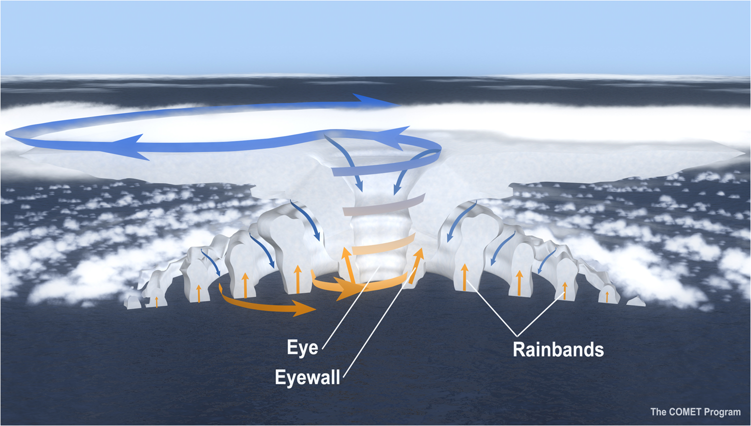
“A hurricane is a strongly rotating vortex… characterized by a … ring of convective clouds swirling around a clear eye in strong hurricanes,” Yau explains. This ring of convection is called the eyewall.
Yau explains that rotational waves in the hurricane move away from the eye, striking the edges of the eyewall and transferring momentum outward. Further from the centre of the hurricane, these rotational waves reach a distance where their interaction with the mean circulation of the vortex initiates a second eyewall outside the initial one.
This secondary eyewall formation happens frequently in hurricanes and makes their behaviour more difficult to forecast, since the process causes rapid changes in the intensity of a hurricane. Depending on where the eyewall occurs, the changes can be devastating.
“If the secondary eyewall forms when the hurricane makes landfall, the radius of [the high] wind and strong precipitation region can expand considerably to cause damage over a much wider area. Such was the case of Hurricane Katrina, when it [made] landfall over New Orleans,” Yau said.
Hurricane Sandy’s incredible impact was not due to secondary eyewall formation, but rather the combined effect of her size and interactions with the northern weather systems. As Sandy moved north towards the U.S., the winding-down hurricane met the mid-latitude system along the East Coast, forming a storm.
“[T]here was a high pressure system over Newfoundland, which [steered] the storm to make landfall over a densely populated area, [causing] significant damage from flooding and strong winds.”
Yau’s computer models are comprised of sets of partial differential equations “describing the changes of momentum, heat, mass and various cloud processes in a hurricane.” Using supercomputers and analysis techniques, he is able to simulate secondary eyewall formation.
“Our study is to simulate the hurricane eyewall replacement cycle, and to understand the processes involved to forecast the intensity change of hurricanes.”
Modeling eyewall replacement cycles in hurricanes is a large step towards understanding these mysterious ‘super-storms’. The models open doors for studying parts of a hurricane that cannot normally be accessed, and have the potential to allow new levels of accuracy in predicting and forecasting hurricanes.