


Nothing about this winter has seemed particularly remarkable. There were no freak snowstorms, no -30 degrees Celsius days—yet, dejection towards the weather remains pervasive throughout campus. By February, checking the weather forecast simply becomes a measure of insanity: Why check when you know that it will produce a nearly identical forecast as the day before?
“I think the primary contributor to the misery this year is persistence,” explained Chair of McGill’s Department of Atmospheric and Oceanic Sciences, professor John Gyakum.
Instead of the news-catching days of extreme temperatures, streaks of cold patterns have made this winter one for the books.
“During the months of January and February, we had a sum total of [only] three days in which the temperatures got as high as zero degrees Celsius or above,” Gyakum said. “Three days, out of 59 days. That has not happened since records were beginning to be taken.”
The overwhelming pattern of cold days spurred an investigation of the winter’s temperature variations. Standard deviation—a measure used to quantify the distribution of data points—can be applied to understand the temperature variability of this past season. For January and February, the standard deviation of temperature values was only 4.1 degrees Celsius, compared to previous wintertime standard deviations averaging in the double digits—indicating past years have had more variation in temperature.
“We have times where we’re stuck in a warm pattern and we have a ton of warm days, and then the next winter, we have a cold pattern where we’re stuck with a lot of cold days,” explained McGill Atmospheric and Oceanic Sciences associate professor Eyad Atallah. “Previously, we would expect that pattern to oscillate. But the last few winters […] have generally been exhibiting this characteristic where we have more persistent weather regimes.”
Despite Montreal horror stories—including ones of temperatures reaching -30 degrees Celsius—record-breaking low temperatures have not been recorded since 1994. Historically, Montreal’s winter climate has been characterized by variability and sunshine. But lately, the weather, or flow, patterns have been noticeably stagnant.
“Overall, the flow pattern is slowing down,” Atallah said. “The speed of the pattern is essentially driven by the difference in temperature difference between the equator and the poles. Now, since the polar regions are warming more quickly than the tropical regions, the difference is actually decreasing over time.”
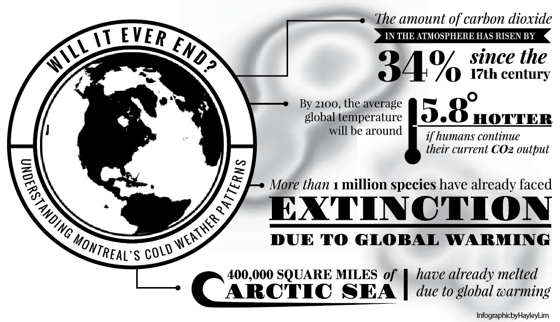
With anthropocentric climate change, many weather processes are being altered due to increased global temperatures. Though it might be hard to believe in the midst of winter, global temperatures are causing a rapid breakup of Arctic sea ice.
“The quality of [Arctic] ice is substantially diminished since it’s less thick, [leading to] openings in the ice to allow heat to be transported from the ocean into the atmosphere,” explained Gyakum.
The melting sea ice sets up a positive feedback loop mechanism: More sea ice lost means more heat transported into the atmosphere, which means more sea ice lost—a dangerous cycle. In other words, the Arctic basin is warming much more quickly than other areas of the world, a phenomenon known as Arctic amplification. Because we’re observing increased temperatures at the poles, the temperature difference between the Arctic and tropical waters is decreasing.
The decrease in extreme global temperature variation is having a dramatic effect on previously well-established weather patterns. With the Arctic warmer than it has ever been, it is no longer always the coldest region in the winter, shifting global wind patterns.
“Three or four decades ago, much of the source region for our bitterly cold air masses that were responsible for getting us well below [-30 degrees Celsius] were initiated in Siberia,” explained Gyakum.
So then why are we not experiencing a warmer winter if we’re receiving warmer Siberian winds? This is due to a ridge of high pressure that is redirecting winds north over Alaska.
“Our winds are persistently directed at us [this winter] from the northwest instead of from the west, and it’s colder because it’s coming from a region of the globe that is ice-locked and has had very little solar radiation this winter,” explained Atallah.
The ridge of high pressure developing over the West Coast of North America began as a consequence of unusual ocean temperatures.
“The pattern we have in the Pacific right now is very reminiscent of something that’s called a Pacific decadal oscillation,” Atallah said.
The Pacific decadal oscillation is a natural phenomenon that has occurred in the past causing the water to be warmer than normal from Mexico to Alaska, and colder than normal in the centre of the Pacific through to Japan. With the oscillation swinging toward its positive side, there has been an increased frequency of warm and dry weather along the West Coast of North America.
“The Pacific decadal oscillation is something we have observed in the past and has a natural oscillation,” Atallah said. “Now you combine that with an increased frequency for the patterns to slow down and for things to be more persistent, and then you have this sort of synergistic feedback between anthropocentric global warming and these natural patterns.”
It’s impossible to derive a single origin or reason for particular weather events. It will always be a complicated marriage of natural phenomena, but with the introduction of the human element in atmospheric manipulation, predictions become even more complicated. Atmospheric scientists use ensemble climate models to make predictions on cold weather patterns.
“The pattern that we’re in right now looks like it will be more common in the next 50 to 100 years,” Atallah said.
Predicting the same high and low temperatures during a specific weather pattern is easy—it’s predicting the beginning and end that is difficult.
What will this new pattern of persistent temperature regimes mean for our day-to-day lives?
“The problem with having persistent patterns [is] if you’re in persistent wet patterns, you’re dealing with floods; if you’re in a persistent dry pattern, you’re dealing with droughts; so the variation [not offered in persistent weather regimes] is key,” Atallah said.
Extreme weather events are more likely when variation is not in the forecast. Without changes in the weather, ecosystems are quickly thrown out of balance as dry spells become longer, and wet seasons turn into floods.
“What [this] means is that the chance of being in a flood or a drought is going to increase, and neither of those things are good,” explained Atallah.
At this point, we have very little control over the short-term weather, but it looks like we should expect more boring persistent winters to come. Consider us lucky, suggest Atallah and Gyakum: The damage of this winter was mostly on our psyche; but for other parts of the world, economically damaging weather patterns are likely in their future.